La Rose du Chapet - No. 8
La Giettaz, Savoie, FR
Min Elevation
1191m
Max Elevation
1923m
Elevation Gain
730m
Elevation Loss
31m
Distance
6.2 km
Est. Time
2h45
About this Track
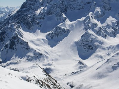
One of the 12 marked ski touring routes across the Portes du Mont-Blanc area. Starting from the Armoy bridge at Le Plan de la Giettaz up to the summit of Tête du Torraz. Far from the alpine ski slopes in a quiet, preserved environment, you will safely enjoy marked routes dedicated to ski touring. A true outdoor sport of freedom in a magnificent setting. At the summit of Tête du Torraz, an XXL orientation table created by artist Arthur Novat helps you name all the surrounding peaks. A truly stunning 360° view!!!
Location
- Country FR
- State/Region Savoie
- City 73590 La Giettaz
- Latitude 45.878470
- Longitude 6.525455
Photos
Community Photos
Photos shared by community members
No community photos yet. Be the first to share!
Login to upload photosNo photos available for this track.
Additional Information
Parking: Parking nearby at Le Plan de la Giettaz.
Access: Departure from the Armoy bridge at Le Plan de la Giettaz.
Safety: Marked routes. Prohibited at night after the resort closes (groomers with winch cables). Possible closure in case of avalanche risk. Pets not allowed (protection zone and sled dogs).
Source
View Original SourceContact Information
Office de Tourisme du Val d'Arly
Auvergne-Rhône-AlpesTourism office for the Val d'Arly region (Flumet, ND de Bellecombe, Crest-Voland, Cohennoz)
Contact Details
-
Address Route des Aravis
73590 Flumet
FR -
Phone +33 4 79 31 06 82
-
Website Visit Website
Elevation Profile
Loading elevation data...
Track Conditions
No condition reports yet. Be the first to report!