Plum Moontain Race
Courchevel, Savoie, FR
Min Elevation
-
Max Elevation
-
Elevation Gain
420m
Elevation Loss
-
Distance
3.0 km
Est. Time
1h15
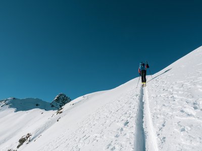
About this Track
Located at the intersection of Courchevel and Méribel, this route leads to Col de la Loze. It offers 360° views of the 3 Vallées from the orientation table at the summit.
Location
- Country FR
- State/Region Savoie
- City 73120 Courchevel
- Latitude 45.423547
- Longitude 6.640623
Photos
Community Photos
Photos shared by community members
No community photos yet. Be the first to share!
Login to upload photosNo photos available for this track.
Additional Information
Parking: Courchevel 1850 car parks
Access: At the start, go up the 'Déviation 1550' piste to the right of the Plantrey chairlift.
Safety: Follow specific marking. In case of low snow, use the Millet route.
Source
View Original SourceContact Information
Courchevel Tourisme
Auvergne-Rhône-AlpesMain tourism office for the prestigious Courchevel resort
Contact Details
-
Address 9 rue de l'Église
73120 Courchevel
FR -
Phone +33 (0)4 79 08 00 29
-
Email info@courchevel.com
-
Website Visit Website
Elevation Profile
Loading elevation data...
Track Conditions
No condition reports yet. Be the first to report!