Remezin
Enchastrayes, Alpes-de-Haute-Provence, FR
Min Elevation
1650m
Max Elevation
2200m
Elevation Gain
550m
Elevation Loss
-
Distance
2.3 km
Est. Time
2h30
About this Track
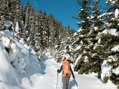
The Remezin route is a ski touring trail that takes you through wooded landscapes and alpine clearings. The route offers a steady climb up to the plateau, providing a wild and preserved setting for practitioners.
Location
- Country FR
- State/Region Alpes-de-Haute-Provence
- City 04400 Enchastrayes
- Latitude 44.368300
- Longitude 6.683300
Photos
Community Photos
Photos shared by community members
No community photos yet. Be the first to share!
Login to upload photosNo photos available for this track.
Additional Information
Parking: Sauze resort parking lot
Access: Access via Sauze 1700 resort
Safety: Ungroomed but marked route. Check opening status before leaving and consult the weather report.
Source
View Original SourceContact Information
Sauze Super Sauze Office de Tourisme
Provence-Alpes-Côte d'AzurTourism Office for Le Sauze Super-Sauze
Contact Details
-
Address Immeuble Le Soleil
04400 Enchastrayes
FR -
Phone +33 4 92 81 05 61
-
Email info@sauze.com
-
Website Visit Website
Track Conditions
No condition reports yet. Be the first to report!