Le Gaschney
Stosswihr, Grand Est, FR
Min Elevation
995m
Max Elevation
1347m
Elevation Gain
286m
Elevation Loss
198m
Distance
2.8 km
Est. Time
-
About this Track
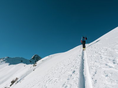
Departure from the route display panel on the edge of the Gaschney station parking lot. Route near the Gaschney ski resort leading to the summit of Petit Hohneck via the Schafferthal pass. A classic itinerary that is often followed, you will find an almost permanent trace. On the way to the Schiessroth hostel (closed in winter) and then on the path to the Schafferthal. Finally, reach the summit of Petit Hohneck, the summit of the ski area. Possible descent by red tracks to reach your starting point.
Location
- Country FR
- State/Region Grand Est
- City 68140 Stosswihr
- Latitude 48.034270
- Longitude 7.046270
Photos
Community Photos
Photos shared by community members
No community photos yet. Be the first to share!
Login to upload photosNo photos available for this track.
Additional Information
Parking: Gaschney station parking lot
Access: Gaschney snow front, Stosswihr
Safety: Stay on the markings, do not park on the downhill ski slope. Be careful, crossing the ascent of a ski lift and a ski slope. Course outside the ski area carried out under the responsibility of the skier.
Source
View Original SourceContact Information
Tourism Office for the Munster Valley in Alsace
Contact Details
-
Address 1 Place du Marché
68140 Munster
FR -
Phone +33 3 89 77 31 80
-
Website Visit Website
Elevation Profile
Loading elevation data...
Track Conditions
No condition reports yet. Be the first to report!