2. La Zigzag (red)
Lens, Valais, CH
Min Elevation
1504m
Max Elevation
2259m
Elevation Gain
755m
Elevation Loss
16m
Distance
5.0 km
Est. Time
2h15
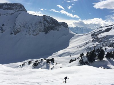
About this Track
The route skirts Lake Chermignon, takes a path through the forest under the blue gondolas and passes through Chetseron before finishing at Cry d'Er.
Location
- Country CH
- State/Region Valais
- City 1978 Lens
- Latitude 46.308707
- Longitude 7.466787
Photos
Community Photos
Photos shared by community members
No community photos yet. Be the first to share!
Login to upload photosNo photos available for this track.
Additional Information
Parking: Parking Crans-Cry d'Er, Route des Téléphériques, 3963 Crans-Montana. Large paying car park with indoor (430) and outdoor (390) spaces. 24h/24.
Access: Accessible from Sierre via SMC bus or funicular. Stop: Crans-Montana, Télé Cry d'Er. By car, A9 motorway exit 'Sierre ouest', follow signs for Crans-Montana.
Safety: Activity overseen by Crans-Montana-Aminona SA during opening hours. Trails closed outside these hours (danger of death: snowcats/winches, avalanches). SOS: 144.
Source
View Original SourceContact Information
Tourism and event organization for the Crans-Montana plateau
Contact Details
-
Address Avenue de la Gare 3
3963 Crans-Montana
CH -
Phone +41 27 485 04 04
-
Email contact@crans-montana.ch
-
Website Visit Website
Elevation Profile
Loading elevation data...
Track Conditions
No condition reports yet. Be the first to report!