Alpine ski touring route – Les Communailles / Télésiège de la Croix
Saint-Gervais-les-Bains, Haute-Savoie, FR
Min Elevation
1423m
Max Elevation
1885m
Elevation Gain
462m
Elevation Loss
-
Distance
3.0 km
Est. Time
1h30
About this Track
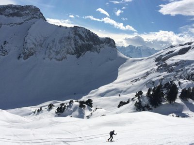
A beautiful getaway between snowy forests and pristine alpine pastures towards the top of the La Croix chairlift. The climb begins gently under the trees before opening onto the wide spaces of Grand Montaz. Spectacular view of Mont Blanc. Descent via the Orgères run.
Location
- Country FR
- State/Region Haute-Savoie
- City 74170 Saint-Gervais-les-Bains
- Latitude 45.864094
- Longitude 6.687084
Photos
Community Photos
Photos shared by community members
No community photos yet. Be the first to share!
Login to upload photosNo photos available for this track.
Additional Information
Parking: Les Communailles car park
Access: Departure at the Communailles ski lift, follow the specific signs.
Safety: Marked but unsecured route. Watch out for grooming machines and avalanche triggers.
Source
View Original SourceContact Information
Saint-Gervais Mont-Blanc Tourisme
Auvergne-Rhône-AlpesTourism Office for Saint-Gervais Mont-Blanc
Contact Details
-
Address 43 rue du Mont-Blanc
74170 Saint-Gervais-les-Bains
FR -
Phone +33 (0)4 50 47 76 08
-
Website Visit Website
Elevation Profile
Loading elevation data...
Track Conditions
No condition reports yet. Be the first to report!