The Panoramic
Huez, Isère, FR
Min Elevation
1800m
Max Elevation
2080m
Elevation Gain
280m
Elevation Loss
-
Distance
2.1 km
Est. Time
-
About this Track
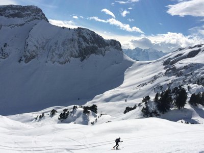
Departure: Grandes Rousses sector (1800m). Arrival: Signal summit. Return via Signal or Marcel slopes. Discovery circuit of the Poutran ridges overlooking the Eau d'Olle valley with a magnificent view of the Belledonne range.
Location
- Country FR
- State/Region Isère
- City 38750 Huez
- Latitude 45.094959
- Longitude 6.071126
Photos
Community Photos
Photos shared by community members
No community photos yet. Be the first to share!
Login to upload photosNo photos available for this track.
Additional Information
Parking: Grandes Rousses sector
Access: Grandes Rousses sector
Safety: Route forbidden if avalanche risk is level 4.
Source
View Original SourceContact Information
SATA Group - Alpe d'Huez Domaine Skiable
Auvergne-Rhône-AlpesSki Area Operator for Alpe d'Huez
Contact Details
-
Address Place Paganon
38750 Alpe d'Huez
FR -
Phone +33 (0)4 76 80 30 30
-
Email info@sataski.com
-
Website Visit Website
Track Conditions
No condition reports yet. Be the first to report!