Savolaire Green Trail / Rando Parc Morgins
Morgins, Valais, CH
Min Elevation
1314m
Max Elevation
1645m
Elevation Gain
320m
Elevation Loss
6m
Distance
3.8 km
Est. Time
1h15
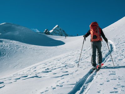
About this Track
A wide, easy trail with gentle slope and beautiful views. Starting from Morgins (Place du 6 Août), take the wide path to Champarin, then climb across the field to the Savolaire Chalet (closed in winter). Enjoy the breathtaking panorama and take a picnic break. Descent follows the same path as ascent, or continue on the blue route to La Foilleuse.
Location
- Country CH
- State/Region Valais
- City 1875 Morgins
- Latitude 46.236590
- Longitude 6.856790
Photos
Community Photos
Photos shared by community members
No community photos yet. Be the first to share!
Login to upload photosNo photos available for this track.
Additional Information
Parking: Parking du 6 Août, in centre of Morgins village
Access: Place du 6 Août, Morgins
Safety: Trails marked but not patrolled. Carry avalanche safety equipment. Taking closed trails at own risk.
Source
View Original SourceContact Information
Part of the Région Dents du Midi, focusing on Morgins and Portes du Soleil
Contact Details
-
Address Route de France 15
1875 Morgins
CH -
Phone +41 24 477 23 61
-
Email morgins@rddm.ch
-
Website Visit Website
Elevation Profile
Loading elevation data...
Track Conditions
No condition reports yet. Be the first to report!