The Forest Path
Vars, Hautes-Alpes, FR
Min Elevation
1860m
Max Elevation
2200m
Elevation Gain
340m
Elevation Loss
-
Distance
2.3 km
Est. Time
2h
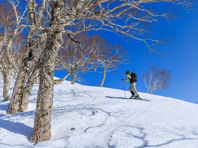
About this Track
Gain altitude and escape into the heart of a larch forest. At the foot of the Mayt chairlift, look for the 'ski de rando' departure sign on your left. Climb through the heart of the forest; wide-open spaces reveal themselves just before the end of the route with an unobstructed view of the Eyssina summit. At the top of the Télémix, the descent is via blue and red slopes.
Location
- Country FR
- State/Region Hautes-Alpes
- City 05560 Vars
- Latitude 44.572693
- Longitude 6.678284
Photos
Community Photos
Photos shared by community members
No community photos yet. Be the first to share!
Login to upload photosNo photos available for this track.
Additional Information
Parking: Vars les Claux
Access: Foot of the Mayt chairlift
Safety: Marked route. Max slope 30%. Consult the avalanche bulletin.
Source
View Original SourceContact Information
Vars Tourisme
Provence-Alpes-Côte d'AzurTourism Office for Vars La Forêt Blanche
Contact Details
-
Address Cours Fontanarosa
05560 Vars
FR -
Phone +33 (0)4 92 46 51 31
-
Email info@vars.com
-
Website Visit Website
Track Conditions
No condition reports yet. Be the first to report!