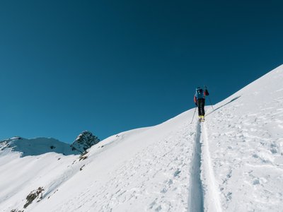
Stanser Joch
Pertisau, Tyrol, AT
Min Elevation
-
Max Elevation
2097m
Elevation Gain
1150m
Elevation Loss
3m
Distance
11.5 km
Est. Time
4h30
About this Track
Very long but rewarding ski tour above Pertisau. The route starts on the cross-country ski trail towards Falzthurntal. Shortly after the start, follow the signs to the left up the mountain through the forest. The ascent continues over the Stanser Nieder to the summit of the Stanser Joch. This tour is physically demanding but offers spectacular views of the Karwendel and Rofan mountains.
Location
- Country AT
- State/Region Tyrol
- City 6213 Pertisau
- Latitude 47.417990
- Longitude 11.741060
Photos
Community Photos
Photos shared by community members
No community photos yet. Be the first to share!
Login to upload photosNo photos available for this track.
Additional Information
Parking: Karwendel valleys car park in Pertisau (paid parking)
Access: By regional bus to Pertisau, stop 'Karwendellift' or 'Karwendeltäler'.
Safety: Alpine experience and very good physical fitness required. Carry full avalanche safety gear.
Source
View Original SourceContact Information
Achensee Tourismus
TirolTourism board for Tirol's largest lake in Austria
Contact Details
-
Address Achenseestraße 63
6212 Maurach am Achensee
AT -
Phone +43 5 95300-0
-
Email info@achensee.com
-
Website Visit Website
Elevation Profile
Loading elevation data...
Track Conditions
No condition reports yet. Be the first to report!