Col de la Madeleine (pedestrian and ski)
Saint-François-Longchamp, Savoie, FR
Min Elevation
1650m
Max Elevation
2000m
Elevation Gain
350m
Elevation Loss
-
Distance
10.0 km
Est. Time
1h
About this Track
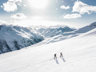
Learn to ski tour in complete safety thanks to our marked route for beginners and intermediates. Finish your journey at the famous Col de la Madeleine, before descending via the downhill slopes. The route, marked with yellow stakes and purple signs, offers a magnificent 360° panorama at the summit with a view of Mont Blanc!
Location
- Country FR
- State/Region Savoie
- City 73130 Saint-François-Longchamp
- Latitude 45.412400
- Longitude 6.347800
Photos
Community Photos
Photos shared by community members
No community photos yet. Be the first to share!
Login to upload photosNo photos available for this track.
Additional Information
Parking: Mollaret area
Access: Departure on the snow front, in front of the Tourism Office, head towards the Col de la Madeleine. Follow the 'La route du tour' track up to the Goélia Les 4 vallées residence (at Plan Mollaret).
Safety: Marked route. Watch out for skiers, stay on the pedestrian path, you do not have priority. Bring snowshoes if there is fresh snow.
Source
View Original SourceContact Information
Office de Tourisme de Saint François Longchamp
Auvergne-Rhône-AlpesTourism office for the ski resort of Saint François Longchamp
Contact Details
-
Address Centre Station
73130 Saint-François-Longchamp
FR -
Phone +33 4 79 60 71 70
-
Website Visit Website
Track Conditions
No condition reports yet. Be the first to report!