Alpine Itinerary
Uvernet-Fours, Alpes-de-Haute-Provence, FR
Min Elevation
2006m
Max Elevation
2336m
Elevation Gain
330m
Elevation Loss
-
Distance
2.5 km
Est. Time
1h30
About this Track
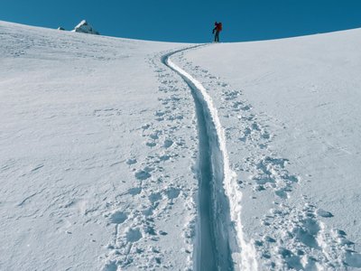
This route offers magnificent views and scenery of the surrounding mountains. The itinerary increases in difficulty with a technical finish. The start is at the arrival of the Télémix at 2006m. Follow the markers and the track through the rocks. After a nice climb, you reach a gentle plateau. Continue to your right and cross the Honoré Bonnet red run. The ascent continues along the ridge to the Péguieou restaurant.
Location
- Country FR
- State/Region Alpes-de-Haute-Provence
- City 04400 Uvernet-Fours
- Latitude 44.368506
- Longitude 6.603158
Photos
Community Photos
Photos shared by community members
No community photos yet. Be the first to share!
Login to upload photosNo photos available for this track.
Additional Information
Parking: Pra Loup 1600 resort car parks
Access: Start at the top of the Télémix (2006m)
Safety: Marked route. Consult the avalanche bulletin. Open from 9am to 5pm depending on conditions.
Source
View Original SourceContact Information
Pra Loup Tourisme
Provence-Alpes-Côte d'AzurTourism Office for Pra Loup ski resort
Contact Details
-
Address Maison de Pra Loup
04400 Uvernet-Fours
FR -
Phone +33 4 92 84 10 04
-
Email info@praloup.com
-
Website Visit Website
Track Conditions
No condition reports yet. Be the first to report!