Le Cernix / Mont-Lachat n°1
Cohennoz, Savoie, FR
Min Elevation
1249m
Max Elevation
1591m
Elevation Gain
342m
Elevation Loss
8m
Distance
2.0 km
Est. Time
1h
About this Track
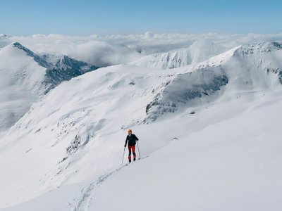
Between slopes and forests, an ideal route for discovery or initiation to ski touring. Departing from the hamlet of Les Frasses, the climb alternates between crossing alpine pastures and a forest atmosphere. At the summit, a splendid panorama awaits you.
Location
- Country FR
- State/Region Savoie
- City 73590 Cohennoz
- Latitude 45.785379
- Longitude 6.500838
Photos
Community Photos
Photos shared by community members
No community photos yet. Be the first to share!
Login to upload photosNo photos available for this track.
Additional Information
Parking: Parking at Le Cernix
Access: Access via Cohennoz / Le Cernix
Safety: Avalanche transceiver, probe, and shovel recommended. Marked but unsecured route.
Source
View Original SourceContact Information
Office de Tourisme du Val d'Arly
Auvergne-Rhône-AlpesTourism office for the Val d'Arly region (Flumet, ND de Bellecombe, Crest-Voland, Cohennoz)
Contact Details
-
Address Route des Aravis
73590 Flumet
FR -
Phone +33 4 79 31 06 82
-
Website Visit Website
Elevation Profile
Loading elevation data...
Track Conditions
No condition reports yet. Be the first to report!