The Mont-Cenis Pass
Val-Cenis, Savoie, FR
Min Elevation
1400m
Max Elevation
2083m
Elevation Gain
683m
Elevation Loss
-
Distance
-
Est. Time
2h
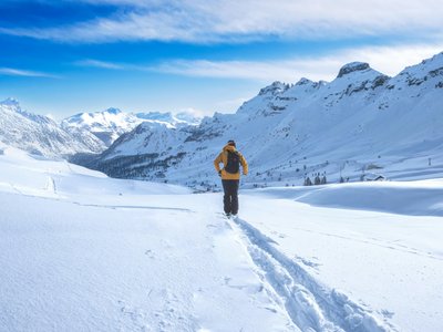
About this Track
Ski touring route designed for safe progression. Departure from the Ramasse snow front to reach the Col du Mont-Cenis. The descent is via the Ramasse red slope or the Escargot green slope.
Location
- Country FR
- State/Region Savoie
- City 73480 Val-Cenis
- Latitude 45.285437
- Longitude 6.890664
Photos
Community Photos
Photos shared by community members
No community photos yet. Be the first to share!
Login to upload photosNo photos available for this track.
Additional Information
Parking: None
Access: Departure from the Ramasse snow front, Lanslebourg-Mont-Cenis.
Safety: Marked route (orange markers). Mandatory safety equipment: transceiver, shovel, probe.
Source
View Original SourceContact Information
Office de Tourisme de Haute Maurienne Vanoise
Auvergne-Rhône-AlpesTourism office for the Haute Maurienne valley
Contact Details
-
Address Place de l'Église
73480 Lanslebourg Mont-Cenis
FR -
Phone +33 (0)4 79 05 99 06
-
Email info@hautemaurienne.com
-
Website Visit Website
Track Conditions
No condition reports yet. Be the first to report!