Pré Rouge
Puy-Saint-Vincent, Hautes-Alpes, FR
Min Elevation
1408m
Max Elevation
2013m
Elevation Gain
611m
Elevation Loss
17m
Distance
4.3 km
Est. Time
1h30
About this Track
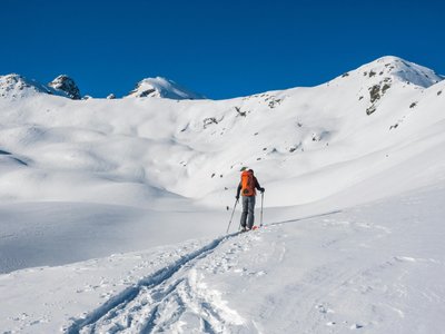
The Rando Ski du Pré Rouge allows you to discover ski touring in a dedicated and secure area in Puy Saint Vincent. The route begins in a forest of larches and birches, offering a marked itinerary ideal for beginners. At the finish, the forest gives way to a beautiful ridge line with a spectacular panorama of the neighboring mountains of the Fournel valley. This route was named the most beautiful route in France by France Montagne in 2019.
Location
- Country FR
- State/Region Hautes-Alpes
- City 05290 Puy-Saint-Vincent
- Latitude 44.826400
- Longitude 6.498110
Photos
Community Photos
Photos shared by community members
No community photos yet. Be the first to share!
Login to upload photosNo photos available for this track.
Additional Information
Parking: Puy Saint Vincent 1400
Access: Departure from the Puy Saint Vincent 1400 m resort (Hôtel Saint Roch) or via the top of the Les Prés chairlift at 1800 m.
Safety: Marked and secured route. Consult the weather and avalanche risks (BRA). Carry full safety equipment (DVA, shovel, probe).
Source
View Original SourceContact Information
Contact Details
-
Phone 06 49 20 63 57
Elevation Profile
Loading elevation data...
Track Conditions
No condition reports yet. Be the first to report!